African Continent.
This section presents a collection of cultures documented through archaeological evidence across the African continent. Each paragraph introduces a culture and provides a brief description of it, along with its systems of measurement, units of length, and short explanations of those units. In cases where sufficient data are available, the units will, of course, be accompanied by conversion tables to modern metric values.
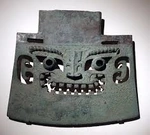
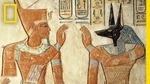
Nabta Playa, Or Pure Evidences of Measurements Used But Even Speculations Will No Define The Units...

About Culture
Nabta Playa is a large dry basin (playa) in the southern Egyptian/Nubian Desert that was seasonally filled and habitable in the early–mid Holocene. Archaeological occupation begins in the early Holocene and intensifies in the 7th–5th millennia BC (radiocarbon ranges for different components span roughly ~7500–4500 BC depending on feature). The environment then supported lakes, wells and pasturage that attracted seasonal or semi-sedentary groups.
Scientific Summary
Evidence shows organized seasonal camps and, later, more permanent village-like layouts with wells that held water year-round. Subsistence included wild plant gathering and, increasingly in the mid-Holocene, pastoralism (domestic cattle, goats/sheep appear in the record), and cultivation/management of plants such as millets/sorghum is suggested in some analyses. Large hearths, pottery and tool assemblages indicate complex, repeated occupation and food processing activities.
Metric System Existed?
Archaeologists have documented tumuli (burial mounds), carved/worked stones, pottery (decorated in later phases), hearths, deep wells, and stone alignments/cromlechs (stone circles). Cattle burials (ritual interment of cattle in clay-lined chambers) are a prominent feature of some phases, indicating the cultural importance of cattle.
The site contains stone alignments and a so-called “calendar circle” (a ring of paired standing stones with internal standing slabs). Several researchers interpret some megalith orientations as pointing to sunrise on the summer solstice and to bright stars — i.e., the site may preserve early archaeoastronomical practice used to mark seasonal events (important for pastoralists tracking rains). However, the precision and intended use are debated; many specialists emphasize that while alignments are plausible, their calendrical accuracy and symbolic meanings remain interpretive.
There is no widely accepted, directly attested standardized ruler/unit of length from Nabta Playa. What exists are geometrical and dimensional analyses of megalith layouts and speculative proposals that patterns reflect implicit measurement schemes. Those proposals range from conservative (geometric/layout relationships) to very speculative (direct numerical length units or “star-distance” scales). Below I summarize main positions and the evidence backing or opposing each.
Some researchers (e.g., Shatalov, Haynie and others in analytic/geometry studies) have suggested the stone circle follows dimensional-geometric relationships — i.e., repeating length ratios and angles that could reflect a working measurement concept (for laying out plans, aligning monuments, or marking seasonal positions). These are mathematical/architectural interpretations based on measured inter-stone distances and angular relationships. They do not prove a named unit like “a Nabta foot” existed, but they do suggest intentional patterning.
A small number of authors (not mainstream archaeologists) have proposed exotic claims — e.g., that the stones encode precise stellar distances or an advanced long-distance astronomical scale (the Brophy “star map / distance scaling” idea is a prominent example). These claims are not accepted by the mainstream archaeological/astronomical community because they rely on selective measurements, disputed correlations, and assume intentions not demonstrated in the field record. Scholarly rebuttals and re-analyses emphasize that such results are not robust given dating uncertainties and measurement/interpretation biases.
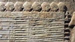
Merimde Beni Salama (commonly called Merimde) 5000 BC Dated. Speculative Measurement Units...

About Culture
Merimde Beni Salama (commonly called Merimde) is located in the western Nile Delta. Occupation dates primarily to the late 6th to early 5th millennium BC (~5000 BC), during the Neolithic period. The site represents one of the earliest sedentary village cultures in the Nile Delta region, contemporary with Buto and other predynastic cultures.
Evidence shows permanent villages with rectangular houses made of wattle-and-daub. Subsistence was primarily agricultural, including cultivation of emmer wheat, barley, and legumes. Animal husbandry included cattle, sheep, goats, and possibly pigs. Fishing and fowling supplemented diets due to proximity to Nile wetlands.
Burials found at Merimde show flexed interments, sometimes with grave goods, suggesting emerging social stratification. The scale of settlement and planning implies some coordinated community management.
Merimde represents a stable, early sedentary community in the Nile Delta. Demonstrates Neolithic innovations: crop cultivation, domesticated animals, settlement planning. These innovations set the stage for later predynastic Egyptian cultural development.
Archaeology In Facts And Speculations
Nevertheless, there are no standardized metric system has been found at Merimde, archaeologists have recorded dimensions of houses, hearths, and storage pits, allowing reconstruction of approximate building modules. Measurements suggest consistent proportions, e.g., houses roughly 4–5 m wide, but this appears practical rather than formalized.
Some researchers suggest that building layouts reflect repeated units (possibly pacing or rope lengths). No artifacts like rulers, marked rods, or inscriptions survive, so any proposed unit is hypothetical.
Assumption may led us to thoughts, that metrics in the culture were based on human-based measures (arm span, step, or pacing) applied consistently in local construction.
Initial Discoveries
The site was first identified by Hermann Junker during his West Delta Expedition in 1928. Excavations were conducted from 1929 to 1939, uncovering domestic structures, lithic tools, and faunal remains
The complex analytical review of old world neolithic the mediterrian basin
In recent years, research into the Neolithisation of both Europe and North Africa has been increasing, notably so into the process by which varied communities adopted new food producing strategies. The implementation of new technology, methods, and theories have contributed to refinements in the timing of change in economies, analysis of the types of food eaten, and the reasons behind these transformations
Revolutions. The Neolithisation of the Mediterranean Basin (Edinburgh Research Explorer)Tassili n’Ajjer Cultures Sahara, Or Continuing Efforts To Find Length Units Evidences...
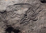
About Culture, And Bovidian or Pastoral Period (6000 - 4000 BC)
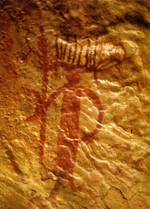
During this era, the Sahara experienced a gradual aridification, leading to the decline of large wild fauna and the emergence of domesticated animals like cattle, sheep, and goats. The rock art from this period vividly depicts these transitions, showcasing scenes of pastoral life, domesticated herds, and human figures engaged in daily activities. Notably, the Running Horned Woman, a prominent painting from this time, illustrates a female figure adorned with bull horns, symbolizing fertility and the integration of cattle into Saharan societies
Archaeological findings in the region, including settlements, tumuli, and enclosures, have yielded abundant ceramic materials, providing further context to the rock art. These artifacts suggest a complex society with developed cultural practices and social structures. The presence of architectural elements in the artwork, such as representations of tents and enclosures, indicates an evolving understanding of space and community organisation
Length Units ..?
While there is no direct evidence of standardized measurement systems (such as units of length or volume) from the Bovidian period, the rock art provides indirect insights into the spatial organisation and scale of prehistoric societies. The depiction of human figures, animals, and architectural elements suggests an understanding of proportionality and spatial relationships.Some researchers have examined the proportions of human figures and animals depicted in the rock art. The consistent use of specific ratios in these depictions suggests an inherent understanding of proportional relationships, which may have served as a rudimentary form of measurement. For instance, vessels with a circumference of one 'royal cubit' were found to hold approximately half a 'hekat' of liquid, indicating an early system of volumetric measurement. The spatial organisation of settlements and enclosures, as inferred from archaeological findings, suggests an understanding of spatial relationships and dimensions, possibly indicating the use of informal measurement units.
Gobero Culture, Southern Sahara...
About Culture
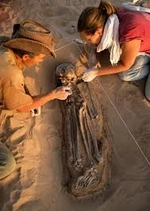
The site sits beside what was once a palaeolake (Lake Gobero), around 3 km in diameter during humid periods. The geology includes paleodune (ancient sand dunes), lake deposits, and a fault ridge in the underlying dinosaur-age sandstone that helps explain water supply sometimes-independent of rainfall. More broadly say, Gobero located in the southern Sahara, in Niger, on the western edge of the Ténéré desert.
There are ~182 burial sites, ~67 excavated in early reports. The early burials (Kiffian) are hyperflexed: bodies tightly flexed (knees to chest etc.).
From the anthropological point of view, we may describe the culture by artfacts, excavated, and include such grave goods as pottery, beads, ivory, bone ornaments; harpoons, hooks, etc.
The Archeological researching propose the summary that common activity of the local population were fishing (tilapia, Nile perch, catfish), use of aquatic fauna (softshell turtles, crocodiles), hunting savannah fauna, collecting plant resources, making tools (stone, bone). In the Tenerian phase some evidence of animal domestication/herding appears, though not a dominant signature in all middens.
Measurements In Gobero ...
Here authors should provide disclamer, that no direct evidences of the measurement units the culture may show to us, what in other words may shaped as: nevertheless Gobero is richly documented in many respects, the archaeological record does not show evidence of any formal or standardized system of length units (like “foot,” “cubit,” etc.). Next couple additional points will arguing the tesis.
No rulers, measuring rods, inscribed linear scale artifacts have been reported in published literature as of now. Archaeological reports have not identified consistent repeated architectural modules (walls, building sizes, or enclosures) that could clearly imply formal measurement units. The middens, pottery, and burials provide size data (e.g. skeleton heights, tool sizes), but these are not evidence of a cultural standard for length — more individual or functional.
But we took upside our own responsibility and here is a field of our suggestions...
The height of people, the sizes of tools and vessels, distances walked (movement around the lake) could be relatively standardized in practice even if informal. For example, measurement of fish sizes, fishhooks, or consistency in tool lengths might imply some “rule of thumb” measures. But no direct evidence. If many implements (stone blades, axes, hafts) have very similar size ranges, that suggests craft traditions with preferred dimensions — this could be a proto-unit standard. But published works focus more on typology of tools rather than exact size standardisation. Burials in cemeteries with patterned placement; habitation/refuse areas near the lake edges and dunes. This may reflect spatial organisation, but not yet shown to use measurement units. Pottery shapes are documented (jars, bowls), and some decorated with standard decorative motifs; whether that implies volume units or size standardisation is not shown.
The Technological and Socio-Economic Organisation of the Elmenteitan Early Herders in Southern Kenya (3000-1200 BP). (By Washington University in St. Louis Washington University Open Scholarship). We recommend our readers to glanse the work, for more deep understanding our suggestions...This article is part of a long-read publication. [Go to the full version →]


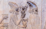
This chapter devoted to two cultures, Babylonia and Persia, and here uncover why...
And here the place we should turning backward, to culture, already passed but under other angle...