Regional Diversity and Urban Polities of the Indus Valley Civilisation
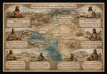
Urban and Regional Structures of the Indus Valley Region
🏰 Kingdom of Mohenjo-Daro (Lower Indus Valley)
Location: Sindh, proximate to the Indus River delta.
Ecology: A riverine and marshland environment, necessitating flood management.
Authority Type: A ritual-bureaucratic theocracy, wherein priest-engineers exercised dominion over waterworks and sanitation.
Cultural Identity: Cosmopolitan, characterised by maritime trade contacts with Mesopotamia and extensive civic planning.
Language: Belonging to the same script family, albeit likely a distinct dialect from that of Harappa, with seal motifs richer in animal totems.
Distinctive Principle: Purity, water-control, and urban hygiene were regarded as sacred state duties.
🏰 Kingdom of Saraswati / Ghaggar–Hakra
Location: Haryana–Rajasthan–Cholistan, situated along the now desiccated Ghaggar–Hakra River.
Ecology: A monsoon-fed seasonal river, forming an agrarian heartland.
Authority Type: A hydraulic-ritual monarchy (Fire-Priest system), wherein state legitimacy derived from ritual fire and water purity.
Cultural Identity: Proto-Vedic spiritualism, evinced by the extensive use of fire altars and ploughed field symbolism.
Language: Perhaps representing a pre-Indo-Aryan linguistic stratum that subsequently influenced early Sanskrit ritual terminology.
Distinctive Principle: The integration of religion and governance, representing an early manifestation of 'sacred kingship'.
🏰 Kingdom of Dholavira (Kutch Island, Gujarat)
Location: Khadir Bet island, ensconced within the Rann of Kutch desert.
Ecology: An arid saline basin, reliant on capacious reservoirs.
Authority Type: A city-state monarchy, governed by a hydraulic engineering elite, characterised by defensiveness and self-reliance.
Cultural Identity: Distinguished by a unique script ordering (fewer animal seals), distinctive bilingual signage, and civic geometry with monumental planning.
Language: Likely affiliated to the western (Elamite–Dravidian) group, exhibiting a highly regionalised vocabulary on seals.
Distinctive Principle: Hydraulic sovereignty, wherein the control of water served as a symbol of legitimacy.
🏰 Kingdom of Lothal (Gujarat Coast)
Location: Near modern Ahmedabad, located at the Sabarmati River estuary.
Ecology: Coastal and deltaic, providing maritime access to the Arabian Sea.
Authority Type: A port-mercantile monarchy or governorate, engaged in trade regulation, customs, and shipping registry.
Cultural Identity: Merchant and artisan-oriented, exhibiting less ritual and more commercial bureaucracy.
Language: Employing the same Indus script, albeit adapted for merchant seals, with evidence of contact-terms with Sumerian.
Distinctive Principle: Commercial authority and external diplomacy, representing a proto-'trade ministry' state.
🏰 Kingdom of Chanhu-Daro (Sindh heartland)
Location: Situated between Harappa and Mohenjo-Daro, along the Indus River.
Ecology: Semi-arid, sustained by irrigation canals.
Authority Type: A guild-administered industrial city-state, wherein civic administration was delegated to the heads of craft guilds.
Cultural Identity: Characterised by a highly specialised economy and a secular, production-oriented society.
Language: Likely employing the same dialect as Mohenjo-Daro, with industrial notations discernible on seals.
Distinctive Principle: Economic corporatism, wherein power derived from productivity, rather than priesthood.
🏰 Kingdom of Amri (Lower Sindh)
Location: South Sindh, situated in the foothills between the Indus plain and Baluchistan.
Ecology: A transitional upland–plain border, facilitating early farming and copper trade.
Authority Type: A fortified proto-kingdom or clan monarchy, engaged in small-scale defence and trade regulation.
Cultural Identity: Distinguished by distinct pottery and architecture, exhibiting semi-independence from the Indus core.
Language: Proto-Dravidian, a pre-urban dialect, with limited script usage.
Distinctive Principle: Border defence and metal exchange, representing local autonomy within a federation.
🏰 Kingdom of Nausharo–Mehrgarh (Baluchistan Highlands)
Location: The Bolan Pass region, proximate to Quetta.
Ecology: A highland farming and copper mining zone.
Authority Type: A tribal-agrarian monarchy, focused on metallurgy, representing a precursor of Indus metallurgy.
Cultural Identity: Exhibiting continuity from Neolithic Mehrgarh, with goddess figurines and mountain totems.
Language: Likely an early Dravidian / Proto-Elamite amalgamation.
Distinctive Principle: Resource sovereignty, wherein control was exerted over minerals, rather than urban trade.
🏰 Kingdom of Surkotada (Kutch–Rajasthan border)
Location: The northeastern Kutch region.
Ecology: A frontier semi-desert, serving as a trade and defence corridor.
Authority Type: A military-frontier principality, tasked with protecting inland trade from nomads.
Cultural Identity: Characterised by a smaller fort layout, and the presence of horse remains (earliest in India).
Language: Employing a western dialect of the Harappan family.
Distinctive Principle: Border defence, cavalry innovation, and customs control.
The Socio-Cultural Conspectus of the Region
Political and Administrative Fabric
The authors have permitted themselves to draw comparisons between the various kingdoms, noting their principal distinctions, which seems appropriate at this juncture in our cultural exploration.
These constituted discrete cultural and political regions, and not uniform provinces.
Diverse languages and dialects likely existed—all employing the Indus script, yet representing a multiplicity of speech communities (Dravidian, Elamo-Dravidian, and early Indo-Iranian tongues).
Authority systems were manifold: some were ritual-theocratic (such as at Saraswati and Mohenjo-Daro), others bureaucratic or commercial (as exemplified by Harappa and Lothal), with a few being military or resource-based (Surkotada and Nausharo).
Federative unity was engendered through shared standards—namely, weights, brick ratios, and a symbolic ideology of order and purity.
| Region | Ecological Type | Authority Model | Cultural-Linguistic Emphasis |
|---|---|---|---|
| Harappa (North) | Fertile plains | Bureaucratic administration | Dravidian-structured language; script formalized |
| Mohenjo-Daro (South) | River delta | Ritual-theocratic | Cosmopolitan; maritime lexicon |
| Saraswati (East) | Semi-arid agrarian | Fire-priest monarchy | Proto-Vedic; ritual Sanskrit precursors |
| Dholavira (West) | Desert island | Hydraulic monarchy | Local dialect; emphasis on civic geometry |
| Lothal (Coast) | Maritime delta | Trade bureaucracy | Trade vocabulary; bilingual seals |
| Chanhu-Daro (Central Sindh) | Semi-arid plain | Guild administration | Industrial vocabulary; numeric notation |
| Amri–Nausharo (Frontier) | Highland fringe | Resource monarchy | Proto-Dravidian metallurgical lexicon |
| Surkotada (Border) | Desert frontier | Defensive principality | Military terminology; cross-cultural seals |
| Relation type | Evidence & nature |
|---|---|
| Trade & economic exchange | Identical seals, weights, and brick ratios observed across a million square kilometres evince an inter-regional economic federation. Harappa exported finished goods southward; Lothal managed overseas cargo; Dholavira superintended desert caravans; and Nausharo supplied copper and stone. |
| Cultural & administrative communication | The uniformity of the writing system, civic engineering style, and metrology suggests continuous coordination—possibly through annual assemblies of priest-administrators or itinerant merchants who maintained consistent standards. |
| Diplomatic or religious unity | Shared iconography (the ‘unicorn’ seal, Pashupati figure, and water/animal motifs) implies a common symbolic order, not unlike the banner of a confederation. |
| Competition & local rivalry | Fortifications, defensive bastions, and shifting trade routes intimate commercial and territorial rivalries rather than large-scale warfare. These may be likened to the city-state competitors of Sumer, such as Ur and Lagash. |
| Conflict scale | No evidence exists of conquest at the empire level or organised warfare—no mass graves or burnt strata comparable to those of Near Eastern wars. Conflicts were more likely economic blockades or brief incursions. |
| Inter-kingdom communication | Riverine and coastal routes linked all nine polities: the Indus–Ravi–Sutlej–Hakra corridor inland, and coastal trade from Lothal and Dholavira down to Oman and up to the Persian Gulf. |
Summarising the landscape of the territory, its habitants, historical evolutionary pathway, the only outcomes we may record:
- - The Indus Civilisation operated as a federation of nine regional kingdoms, each self-governing yet bound by a shared technical and moral order: civic cleanliness, standard weights, and regulated exchange.
- - No singular ‘empire’ held dominion over the rest; power was distributed, balanced through trade and a shared ideology.
- - Their system endured for six to seven centuries—exceeding the lifespan of most Bronze-Age monarchies—owing to the fact that cooperation outweighed conquest.
Standardisations and Administrative Approaches Among the Proto-States of the Indus Valley
Measurement Systems
Let us now consider the measurement systems, and their respective rates, employed in the Indus Valley, with a view to elucidating the transition from mere cultural background to a precise metrological approach.
It is pertinent to note at the outset certain salient features which demand clarification, notwithstanding minor regional variations (of approximately ±1 cm per cubit, and ±1 % per weight). All nine kingdoms adhered to the following:
- - A binary–decimal weight system premised upon ≈ 13.6 g.
- - A linear cubit of ≈ 33–34 cm, divisible into 30 sub-divisions (each approximately 1.1 cm).
- - A brick ratio of 1 : 2 : 4, defining a modular system of architecture.
| Kingdom | Local Cubit (cm) | % Difference vs Harappa | Relation to 1 m | Relation to Each Other |
|---|---|---|---|---|
| Harappa | 33.5 cm | — | 1 m = 2.985 cubits | Base standard |
| Mohenjo-Daro | 33.5 cm | 0 % | 1 m = 2.985 cubits | Identical to Harappa |
| Saraswati / Ghaggar–Hakra | 33.8 cm | +0.9 % | 1 m = 2.958 cubits | +1 % longer than Harappa |
| Dholavira | 34.5 cm | +3.0 % | 1 m = 2.90 cubits | +3 % longer; same as Lothal |
| Lothal | 34.0 cm | +1.5 % | 1 m = 2.94 cubits | Within ±1 % of Dholavira |
| Chanhu-Daro | 33.5 cm | 0 % | 1 m = 2.985 cubits | Same as Harappa & Mohenjo-Daro |
| Amri | 30.0 cm | −10.4 % | 1 m = 3.33 cubits | 10 % shorter — pre-standard form |
| Nausharo–Mehrgarh | 33.0 cm | −1.5 % | 1 m = 3.03 cubits | ≈ Harappan range |
| Surkotada | 33.7 cm | +0.6 % | 1 m = 2.97 cubits | Within 1 % of Harappa |
| Kingdom | Local Base Weight (g) | % Difference vs Harappa | Binary/Decimal Progression | Relation to Each Other |
|---|---|---|---|---|
| Harappa | 13.60 g | — | 1, 2, 4, 8, 16, 32… ; 160, 320, 640… | Base reference |
| Mohenjo-Daro | 13.65 g | +0.4 % | Identical progression | Equal precision |
| Saraswati / Ghaggar–Hakra | 13.70 g | +0.7 % | 1, 2, 4 … Hematite variants | Within 1 % of Harappa |
| Dholavira | 13.80 g | +1.5 % | Same progression | Slightly heavier series |
| Lothal | 13.65 g | +0.4 % | Dockyard sets; maritime use | Matches Mohenjo-Daro |
| Chanhu-Daro | 13.55 g | −0.4 % | Industrial duplicates | Matches Harappa |
| Amri | 12.00 g | −11.8 % | Pre-Harappan irregular | Proto-system |
| Nausharo–Mehrgarh | 14.00 g | +2.9 % | Early cone weights | Transitional form |
| Surkotada | 13.60 g | 0 % | Frontier chert cubes | Identical to Harappa |
| Kingdom | Base Volume | Metric Equivalent | Relation to Harappa | Functional Context |
|---|---|---|---|---|
| Harappa | 1 grain-jar | ≈ 0.8 L | Base standard | Civic storage & tithe measure |
| Mohenjo-Daro | 1 box unit | 0.8–0.9 L | ± 5 % | Granary compartments |
| Saraswati / Kalibangan | Bin module | 0.75 L | −6 % | Fire-altar & offering grain |
| Dholavira | Water-jar | 1.0 L | +25 % | Hydraulic storage |
| Lothal | Dock crate | 1.2 L | +50 % | Customs inspections, ship cargo |
| Chanhu-Daro | Workshop jar | 0.4–0.8 L | −20 – 0 % | Craft batching |
| Amri | Pit bowl | ≈ 0.7 L | −12 % | Pre-standard domestic use |
| Nausharo–Mehrgarh | Pottery jar | 0.75 L | −6 % | Neolithic continuity |
| Surkotada | Domestic jar | 0.8 L | 0 % | Household storage |
The Cultural Diversity of the Indus Valley Region: A Synopsis
A Collation of Comparative Tables
In this section, we shall endeavour to amalgamate various rivulets of investigation into a single, coherent stream of conclusions, encompassing prehistoric cultures and emergent kingdoms. The question remains whether our predictions, predicated upon incomplete data and, admittedly, a speculative scoring method, shall prove veracious.
From Neolithic–Chalcolithic Cultures → Indus Kingdom System (7000–1900 BCE)
| Prehistoric / Regional Culture | Timeframe (approx.) | Fate in History | Successor Kingdom(s) or Region | Nature of Transformation |
|---|---|---|---|---|
| Mehrgarh (Kachi Plain, Baluchistan) | 7000–3300 BCE | Transformed | → Nausharo–Mehrgarh Kingdom (Baluchistan Highlands) | Became the metallurgical and agricultural foundation of the early Indus civilisation; continuity observed in farming practices, copper utilisation, and bead craftsmanship. |
| Kili Gul Mohammad / Mundigak (Afghan Border) | 6000–3500 BCE | Absorbed, subsequently diminished | → Western Frontier of Nausharo polity | Early trade relations with Iran & Central Asia waned after 2500 BCE; the population assimilated into the Indus highland periphery. |
| Kot Diji / Ravi Phase (Upper Indus) | 4000–2600 BCE | Evolved | → Harappa Kingdom (Upper Indus Basin) | Developed standardised bricks, fortified walls, and script marks, thereby serving as a direct antecedent to Harappa’s urban bureaucracy. |
| Amri–Nal Horizon (Sindh–Baloch Border) | 3500–2600 BCE | Evolved | → Amri Kingdom & Mohenjo-Daro Zone | Proto-urban pottery and fort layouts presaged the southern administrative network under the later Indus federation. |
| Sothi–Siswal / Early Kalibangan (Ghaggar–Hakra) | 3800–2600 BCE | Transformed | → Saraswati / Ghaggar–Hakra Kingdom | Villages coalesced into ritual-hydraulic towns, exhibiting continuity in fire-altars and field arrangements. |
| Anarta & Sorath Traditions (Gujarat–Kutch–Saurashtra) | 3700–1900 BCE | Merged and Survived | → Dholavira, Lothal, Surkotada Kingdoms | Local coastal and desert cultures coalesced into a maritime confederation, maintaining a degree of autonomy into the Late Harappan period. |
| Ahar–Banas Culture (Rajasthan) | 3000–1500 BCE | Partially Survived | → Traded with Harappa; later → absorbed by Vedic Janapadas | Supplied copper northward; persisted as a post-Harappan rural culture. |
| Northern Frontier / Burzahom–Gufkral Complex (Kashmir–Himalaya) | 4000–1800 BCE | Survived outside Indus core | → Linked to Central Asian steppe; later Indo-Iranian contacts | Never urbanised; continued a Neolithic existence into the Iron Age. |
| Deccan Neolithic–Chalcolithic (Inamgaon, Daimabad) | 2500–1500 BCE | Independent development | → Deccan Bronze traditions; later Satavahana core region | Influenced by Indus metallurgy, yet remained politically distinct from the Indus federation. |
| Indus Kingdom | Root Culture(s) | Degree of Continuity | Result |
|---|---|---|---|
| Harappa | Kot Diji, Ravi Phase | Direct, full | Urban bureaucratic heartland |
| Mohenjo-Daro | Amri–Nal Horizon | Strong | Major southern capital; maritime trade core |
| Saraswati / Ghaggar–Hakra | Sothi–Siswal / Early Kalibangan | Direct | Eastern ritual-hydraulic monarchy |
| Dholavira | Anarta + Sorath | Full regional evolution | Desert-island hydraulic monarchy |
| Lothal | Anarta + Sorath | Full | Port-mercantile kingdom; maritime federation |
| Surkotada | Sorath extension | Direct | Frontier fort and military kingdom |
| Chanhu-Daro | Amri–Nal | Strong | Industrial guild city-state |
| Amri | Amri–Nal Early | Continuity | Proto-urban fort kingdom |
| Nausharo–Mehrgarh | Mehrgarh Highland Culture | Direct | Highland resource kingdom; earliest roots of Indus society |
| Culture | Reason for disappearance | Outcome |
|---|---|---|
| Kili Gul Mohammad / Mundigak | Trade routes shifted eastward; isolation after 2600 BCE | Abandoned, absorbed by Indus highlands |
| Amri–Nal (as independent) | Integrated into a wider Indus trade system | Lost independence, traditions persisted in pottery |
| Sothi–Siswal (as separate) | Merged under Saraswati urbanism | Absorbed into eastern Indus ritual states |
| Culture | Later manifestation |
|---|---|
| Ahar–Banas | Copper trade continued into Early Vedic Rajasthan cultures |
| Anarta & Sorath | Persisted in Dholavira–Lothal crafts into Late Harappan (down to ~1700 BCE) |
| Deccan Chalcolithic | Continued independently; linked to Daimabad bronze tradition (~1500 BCE) |
| Burzahom–Gufkral | Survived as pastoral-agricultural upland cultures until Iron Age; possible Indo-Aryan interface |
Scientific Experiment
The experiment conditions
And now, the hour has arrived to scrutinise our prediction scores from the commencement of our investigations:
Extinct cultures unearthed herein (predicated upon verifiable facts), indexed within our prognostications as follows:
- [0](Kachi Plain, Bolan Pass, Quetta, and Afghan border regions), for this culture, we registered a score of +5.
- [1](Indus Upper Basin (Punjab Region – Ravi, Beas, Sutlej Rivers)), we attributed a score of 2.
- [2](Sindh and the Lower Indus Basin), our evaluation regarding the success in continuous development stands at +6.
- [3](Ghaggar–Hakra (Sarasvati) Region — Eastern Indus Fringe), these tribes garnered a score of 4.
- [4](Gujarat, Kutch, and Saurashtra Peninsula (Dholavira, Lothal, Rangpur, Surkotada, Kuntasi, Loteshwar, Nagwada, Bagasra)), our predictive assessment rated them at 4.5.
- [5](Rajasthan and the Ahar–Banas Cultural Zone (Ahar, Gilund, Balathal, Ojiyana, Bagor (earlier Neolithic))), we adjudged this culture with a score of 6.
- [6](Northern Frontier and Himalayan Foothills (Burzahom, Gufkral (Kashmir), Mandi (Himachal), Sarai Khola (Potwar Plateau, N. Pakistan), Loebanr, Ghaligai (Swat Valley))), their potential was rated at 1.5.
- [7](Central Indian Plateau and Deccan Neolithic (Chirand (Bihar, eastern fringe), Inamgaon, Nevasa, Daimabad, Tekwada, Kayatha, Navdatoli (Madhya Pradesh and Maharashtra regions))), our estimation yielded a score of 6.
Below, we shall furnish a table exhibiting empirical data alongside our prognostications. Should our predictive rate fall below 3, it is posited that the tribe in question did not endure; conversely, we denote a green V as an index of partial adaptability. Conversely, should a tribe have vanished despite our attribution of a high value, this is construed as a misprediction.
| index | rate | period | tribe | fate | success/unsuccess |
|---|---|---|---|---|---|
| [0] | 5 | 7000–3300 BCE | Mehrgarh (Kachi Plain) | Survived and transformed | ✅ |
| [0] | 5 | 3300–2600 BCE | Nausharo | Fully survived (absorbed) | ✅ |
| [0] | 5 | 6000–3500 BCE | Kili Gul Mohammad (near Quetta) | Vanished / absorbed | ❌ |
| [0] | 5 | 5000–3000 BCE | Mundigak (southern Afghanistan) | Vanished independently | ❌ |
| [1] | 2 | 4000–2600 BCE | Kot Diji | Transformed → Survived | ❌ |
| [1] | 2 | 3500–2800 BCE | Ravi Phase (Harappa I levels) | Fully survived | ❌ |
| [1] | 2 | 3500–2800 BCE | Kalibangan I (early phase) | Merged eastward | ❌ |
| [1] | 2 | 4000–3000 BCE | Jalilpur | Vanished / absorbed | ✅ |
| [2] | 6 | 3600–2600 BCE | Amri–Nal Horizon (Sindh–Baloch border) | Transformed → Survived | ✅ |
| [2] | 6 | 2600–1900 BCE | Mohenjo-Daro (DK-G, DK-A, HR areas) | Fully survived (until late Harappan) | ✅ |
| [2] | 6 | 2600–1900 BCE | Chanhu-Daro | Survived partially (industrial) | ✅ |
| [2] | 6 | 3500–2600 BCE | Kot Diji (southern) | Merged upward | ✅ |
| [2] | 6 | 1900–1500 BCE | Jhukar Culture (Late Harappan, post-1900 BCE) | Partial survival | ❌ |
| [3] | 4 | 3800–2600 BCE | Sothi–Siswal Culture (pre-Harappan) | Transformed → Survived | ✅ |
| [3] | 4 | 3500–1900 BCE | Kalibangan I–II | Fully survived into Mature Harappan | ✅ |
| [3] | 4 | 4000–2000 BCE | Bhirrana | Survived longest | ✅ |
| [3] | 4 | 3000–1800 BCE | Banawali | Survived → declined slowly | ✅ |
| [3] | 4 | 3500–1900 BCE | Rakhigarhi | Survived fully | ✅ |
| [4] | 4.5 | 3700–2500 BCE | Anarta Tradition (North Gujarat) | Transformed → Survived | ✅ |
| [4] | 4.5 | 2600–1900 BCE | Sorath Harappan Culture (Saurashtra & Kutch) | Fully survived | ✅ |
| [4] | 4.5 | 3000–1800 BCE | Dholavira | Survived longest | ✅ |
| [4] | 4.5 | 2400–1900 BCE | Lothal | Survived (later ruralized) | ❌ |
| [4] | 4.5 | 2300–1700 BCE | Surkotada | Survived partially | ✅ |
| [4] | 4.5 | 2500–1500 BCE | Rangpur, Kuntasi, Loteshwar | Survived as Late Harappan | ✅ |
| [5] | 6 | 5000–3000 BCE | Bagor (Neolithic precursor) | Transformed → Survived | ✅ |
| [5] | 6 | 3000–1500 BCE | Ahar (Udaipur region) | Survived fully | ✅ |
| [5] | 6 | 2600–1500 BCE | Gilund | Survived → Declined gradually | ❌ |
| [5] | 6 | 3000–1500 BCE | Balathal | Survived long | ✅ |
| [5] | 6 | 2200–1600 BCE | Ojiyana | Partial survival | ✅ |
| [6] | 1.5 | 3000–1800 BCE | Burzahom (Kashmir Valley) | Survived long | ❌ |
| [6] | 1.5 | 4000–2000 BCE | Gufkral (Kashmir) | Survived → ruralized | ✅ |
| [6] | 1.5 | 3500–2000 BCE | Mandi (Himachal Foothills) | Partially survived | ❌ |
| [6] | 1.5 | 3300–2000 BCE | Sarai Khola (Potwar Plateau) | Absorbed / transformed | ❌ |
| [6] | 1.5 | 2400–1700 BCE | Swat Valley (Loebanr–Ghaligai complex) | Survived → evolved | ❌ |
| [7] | 6 | 2400–2000 BCE | Kayatha Culture (Madhya Pradesh) | Transformed → Survived | ✅ |
| [7] | 6 | 2000–1500 BCE | Malwa Culture | Survived fully | ✅ |
| [7] | 6 | 2200–1500 BCE | Daimabad (Maharashtra) | Survived → evolved | ✅ |
| [7] | 6 | 1800–1200 BCE | Inamgaon | Survived | ✅ |
| [7] | 6 | 2000–1500 BCE | Nevasa | Partially survived | ❌ |
| [7] | 6 | 2500–1500 BCE | Chirand (Bihar) | Survived | ✅ |
As one may observe, within our artifice, we have elected not to employ intricate datasets replete with exhaustively detailed descriptions pertaining to each culture, their characteristic attributes, multi-faceted perspectives for data filtration, nor a plethora of commonly utilised methodological instruments. Nonetheless, as a mere pastime, the collective aspiration of the authors resides in the notion that the experience has proven intellectually stimulating. Furthermore, the juncture has arrived to effect a relocation — specifically, to a region that harbours no paucity of enigmas and brims with prospective revelations concerning the cultural and socio-constructional tenets underpinning the architecture of human society...