Prehistoric Indus Valley: Regional Cultures and the Rise of Harappan Urbanism
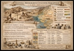
Prehistorical Map of the Indus Valley
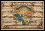
The geographical ambit of this region extended prodigiously, from the littoral between Iran and Pakistan in the west, proximate to the modern Delhi in the east, and reaching into Afghanistan in the north.
Nevertheless, the tribal sites were principally established along the fluvial margins of the Indus River basin, constituting the very nucleus of our present inquiry.
For the purposes of generalisation, we may partition the region into eight distinct sectors, each exhibiting a unique character, both territorially and chronologically.
Let us now consider these sectors seriatim, emulating the unhurried flow of rivers, and with due deference to the grandeur of the landscape we shall be traversing.
🏕️ Baluchistan Highlands (Mehrgarh and Associated Valleys)
Sites within this territory include: Mehrgarh (Kachi Plain), Kili Gul Mohammad, Nausharo, Mundigak (Afghan border).
Archaeological investigations have revealed the following settlements:
- Early domestication of wheat, barley, and zebu cattle (a proposition advanced by researchers, though speculative).
- Mud-brick habitations comprising multiple chambers (speculative, yet plausible).
- Sepulchral sites containing adornments fashioned from lapis lazuli, turquoise, and marine shells (indicative of trade connections).
- Early copper implements and workshops dedicated to bead manufacture.
The populace here represented early agro-pastoral communities, occasionally identified with pre-Dravidian or proto-Indus substrata. The Mehrgarh culture is esteemed as the cradle of South Asian Neolithic civilisation, disseminating agricultural expertise eastward to the Indus plains (a position indirectly held by researchers, for the most part).
The temporal framework of the sites under review is delineated as 7000–3300 BCE.
🏕️ Indus Upper Basin (Punjab – Ravi, Beas, Sutlej Region)
We allude here to the period spanning 4000–2600 BCE.
- Settlements: Harappa, Kot Diji, Kalibangan I (early phase), Jalilpur.
Grounds for our conjectures (sometimes pertaining to actual archaeological artefacts):
- Development of towns enclosed by mud-brick walls, diminutive citadels, and granaries (suggested, indirectly).
- Handmade pottery adorned with geometric motifs (actual artefacts).
- Discovery of terracotta bull figurines, plough marks (Kalibangan), and seed remains indicative of organised agriculture (a speculative suggestion, yet deserving of consideration as a theory).
- Increasing standardisation of brick dimensions and proto-writing marks upon pottery (inferences drawn from the artefacts, highly probable).
- Associated with the Kot Diji culture, conceivably descended from Mehrgarh settlers who migrated eastward. This region likely encompassed riverine agricultural clans and trade syndicates linking hill and plain (inferences predicated upon generalised complex research).
🏕️ Sindh and the Lower Indus Basin
The period under scrutiny here extends from 3500–2600 BCE.
- Settlements under consideration: Amri, Mohenjo-daro (early levels), Chanhu-Daro, Kot Diji (southern type).
- Sources and speculations to be listed include pottery embellished with painted patterns and wheel-made ceramics.
- Early fortified towns exhibiting planned street grids.
- Copper implements, shell ornaments, and faience objects.
- Increasing employment of standardised weights and nascent trade with southern Mesopotamia (Dilmun–Ur) (inferences and suggestions based upon artefacts).
All aforementioned considerations incline us towards the outcome recognised as the Amri–Nal cultural horizon in its early phases. The tribal identity remains uncertain, yet likely pertains to proto-urban trade groups fostering long-distance connections. Their descendants evolved into the core urban population of Mohenjo-daro.
🏕️ Ghaggar–Hakra (Sarasvati) Region — Eastern Indus Fringe
Though it may appear inconsistent chronologically, we are not governed by temporal congruity; rather, we are surveying the rivers’ banks, site by site. Thus, the period we are presently examining in this region is dated as 3800–1900 BCE.
- The sites identified here include: Kalibangan I–II, Bhirrana, Banawali, Rakhigarhi.
- And what of the artefacts with which researchers furnish us? Early farming villages developing into towns along the desiccated Ghaggar–Hakra (often identified with the mythical Sarasvati River). And this assertion possesses a basis, founded upon the ensuing evidence.
- Kiln-fired brick architecture and grid-like layouts, seals, weights, and bead workshops utilising semi-precious stones (agate, carnelian) (partially derived from excavations, yet logically tenable).
Continuous occupation from pre-Harappan to mature Harappan epochs (a claim that is assuredly disputable).
And now, a moment for conjecture. The region reveals continuity from the Sothi–Siswal culture, possibly comprising small farming clans who subsequently integrated into the broader Indus network. They played a significant role in maintaining the eastern trade and agricultural frontier.
🏕️ Gujarat, Kutch, and Saurashtra Peninsula
The temporal context shifts us to the 3700–1900 BCE epoch, encompassing the settlements of Dholavira, Lothal, Rangpur, Surkotada, Kuntasi, and Loteshwar. Of course, the nomenclature adheres to our modern reconstructed orthography, yet such is what we possess.
The evidence affords us the following: fortified towns replete with reservoirs and water-management systems (notably Dholavira). Evidence of salt extraction, shell processing, and maritime trade — assuredly hypotheses, yet nevertheless meriting consideration as well-balanced arguments concerning the human activity of the inhabitants of these sites.
- Early employment of stone weights and proto-script marks derived from the excavated artefacts.
- Lothal’s dockyard evinces international commerce with the Persian Gulf.
- From all the above, we may posit that this region accommodated the Anarta and Sorath traditions, representing local adaptations to the arid coastal ecology. Populations were adept in trade and seafaring — likely proto-Dravidian speakers or coastal merchant tribes.
🏕️ Rajasthan and the Ahar–Banas Cultural Zone
The period, archaeologically dated to 3000–1500 BCE, and the artefacts reveal to us the pastoral sites of Ahar, Gilund, and Balathal.
- What revelations do the excavated remains yield?
- Chalcolithic settlements featuring copper implements, wheel-made pottery, and mud-brick platforms as artefacts; and from the evident inferences, we may conclude that these are agricultural sites displaying evidence of barley, lentil, and rice cultivation.
- A distinctive ceramic style: black-on-red ware. Copper-smelting furnaces have been discovered, attesting to independent metallurgical expertise.
Conjecture, as our peculiar fashion dictates? The Ahar–Banas culture was semi-independent, yet interacted with the Harappans through trade. The tribes here controlled copper resources and furnished materials northward. Some continuity is discernible in later early-historic cultures of Rajasthan.
🏕️ Northern Frontier and Himalayan Foothills
- Our chronicle now leaps to the 4000–1800 BCE period. The settlements commended to us by archaeologists include Burzahom (Kashmir), Gufkral, Mandi, and Sarai Khola.
- The corpus of excavations and unearthed artefacts enumerates the following evidence: pit dwellings, bone implements, hunting and fishing apparatus.
- Domestication of sheep, goats, and cereals (especially in Kashmir) may be surmised from the excavated finds.
- Interaction zones between Central Asian and Indian Neolithic groups may be postulated for these settlements, based upon their location and artefacts.
- A speculative summary may also find its place here: populations possibly related to early Tibeto–Burman and Indo-Iranian migrations. They sustained mountain trade links, conveying jade, turquoise, and obsidian southward.
🏕️ Central Indian Plateau and Deccan Neolithic (Peripheral Influence)
The temporal context related to the settlements’ period we are endeavoring to describe encompasses 2500–1500 BCE.
- The territory reveals to us, through discoveries by researchers, settlement sites such as Chirand, Inamgaon, Nevasa, and Daimabad.
- Scientists have performed commendable work in providing us with the evidence and outcomes concerning the lives of the regional inhabitants of the aforementioned period.
Neolithic to Chalcolithic farming villages employing stone axes and copper implements serve as evidence of rice cultivation, cattle herding, and long-distance trade in beads and metals.
- Underscoring the facts and suggestions enumerated above, we conclude that the Deccan populations were distinct, yet influenced by northern contacts. Daimabad has yielded a bronze chariot sculpture, symbolically linking southern metallurgy with the Indus artistic tradition.
A Scientific Game of Classification
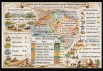
Herein, the authors shall demonstrate, in a rigorously systematic and scientific manner, the construction of a theory, the formulation of a hypothesis, and the subsequent derivation of outcomes, establishing these as discernible patterns. In the ensuing stage of this research procedure, said patterns shall be subjected to meticulous examination to ascertain their verisimilitude.
Thus, we possess a collection of cultures (a detailed enumeration whereof is superfluous at this juncture—let a cursory glance at the preceding paragraph suffice). And what actions ought scientists to undertake? It is known, through experience, that every organism localised within a specific territory accrues certain characteristics dictated by environmental determinants. For instance, the hippopotamus is so shaped by the exigencies of its locale that it necessitates the presence of lakes replete with mud, swamps, shores abundant in flora and grasses—principally shrubs—a temperature range confined within a defined spectrum, and other pertinent environmental conditions. A dramatic alteration of these conditions precipitates a decline in the species’ population and may even culminate in its extinction. These inherent predispositions provide a schema for the collection of data, its subsequent generalisation, and its classification into sets of objects, which, in turn, furnish the predictive efficacy of the scientific method.
Following the aforementioned principles, let us proceed to classify the enumerated cultures. From the cultural attributes delineated, we may generalise them into two principal groups predicated upon their specialisation of activity. These categories are: the fabrication of metallic artefacts (denoting a fundamental comprehension of metallurgy), the rudiments of agriculture, the domestication of animals, and the exploitation of riverine fauna as a substantial supplementary resource.
Now, to the stage of classification. We shall designate Index 0 to the Baluchistan Highlands. Each culture shall be scored based upon its cumulative evaluation, wherein metallurgical acumen is assigned a value of +2, domestication +1, agriculture +1, and the utilisation of piscatorial resources +0.5. Thus, for Index 0, we score [0] = metal(+2), domestication(+1), trading(+2). The Indus Upper Basin (Index 1) yields [1] = domestication(+1), agriculture(+1). Sindh and the Lower Indus Basin (Index 2) yield [2] = trading(+2), metal(+2), agriculture(+1), domestication(+1). The Ghaggar–Hakra (Sarasvati) Region (Index 3) yields [3] = domestication(+1), agriculture(+1), trading(+2). Gujarat, Kutch, and the Saurashtra Peninsula (Index 4) yield [4] = fishing(+0.5), trading(+2), agriculture(+1), domestication(+1). Rajasthan and the Ahar–Banas Cultural Zone (Index 5) yield [5] = metal(+2), trade(+2), domestication(+1), agriculture(+1). The Northern Frontier and Himalayan Foothills (Index 6) yield [6] = fishing(+0.5), domestication(+1). The Central Indian Plateau and Deccan Neolithic (Index 7) yield [7] = metal(+2), trade(+2), agriculture(+1), domestication(+1).
Pre-calculation shall reveal the following valuations: [0]:5, [1]:2, [2]:6, [3]:4, [4]:4.5, [5]:6, [6]:1.5, [7]:6. And these numerical ratings we shall term the developmental scale of proto-society.
It is crucial to note that this section is purely speculative in nature, designed to elucidate the methodologies of classification and evaluation, and does not purport to present verifiable scientific facts. In the ensuing discourse, we shall explore the genuine historical evolutionary processes operative within the territory and compare them with the predictive schemata sketched herein.
The Indus (Harappan) Civilisation
Transition from Mehrgarh to Early Harappan (circa 3500–2600 BCE)
Subsequent to the late Chalcolithic period at Mehrgarh, the Kachi Plain and its adjacent valleys (Nausharo, Mundigak, Damb Sadaat) evolved into regional centres, interconnected through mercantile activities and the dissemination of shared cultural attributes.
The Indus (Harappan) Civilisation — The Inaugural Veritable “Statehood” (circa 2600–1900 BCE): Formation of the Mature Harappan State: By approximately 2600 BCE, the cultural unification spanning Baluchistan, Sindh, Punjab, and northwestern India engendered the primogenial state system in the South Asian subcontinent.
Baluchistan functioned as the western adjunct of this civilisation. Sites such as Nausharo and Mehrgarh (during their latter phases) constituted integral components of the Harappan economic network, potentially serving as purveyors of metals and minerals to the principal Indus metropolises.
Collapse of the Harappan State (circa 1900–1300 BCE): The aetiology precipitating the collapse may be enumerated as follows: climatic aridification (desiccation of the Ghaggar–Hakra fluvial system), a decline in mercantile exchange with Mesopotamia, and localisation and fragmentation into diminutive regional cultures (Late Harappan phase).
Cultural Successors in Baluchistan: Jhukar Culture (Sindh and Baluchistan) and Kulli Culture (southern Baluchistan, characterised by fortified towns and local chiefdoms) both epitomised post-urban, ruralised polities or chiefdoms, exhibiting limited bureaucratic structures yet a discernible elite presence.
Subsequent to the fragmentation of the Harappan world, Iranian and Indo-Aryan factions commenced to exert dominance over the broader region. Towards the east (Punjab, Indus Basin), Indo-Aryan tribes established janapadas—tribal proto-kingdoms that would subsequently engender the Mahajanapadas of India. Baluchistan, by virtue of its peripheral situation, oscillated between Iranian and South Asian cultural domains.
The Indus (Harappan) System of Measurement
It doth behove us now to present the cultural system of measurement. To obviate fragmentation amongst the units, we shall confine our attention precisely to the period circa 2600–1900 BCE (Mature Harappan Phase), observing that the system did largely evolve from antecedent regional practices (e.g., those of the Mehrgarh and Early Harappan Amri–Kot Diji cultures).
As a classificatory factor, we may posit that the system possessed characteristics of standardisation and decimalisation (base 10 and multiples of 2), exhibiting uniformity across a distance exceeding 1500 km—from Harappa to Dholavira—thereby suggesting central regulation; it was employed in commerce, taxation, architecture, and divers crafts, and mayhap constitutes one of the earliest known state-wide metrical systems.
Ere we present the units, it is incumbent upon us to clarify certain linguistic and cultural annotations.
Continuity of ‘Karsha’ (≈ 13.6 g): The Arthaśāstra and early Buddhist texts make use of the 'karsha' or 'suvarna' as a standard weight in matters of trade. Its mass (≈ 13.5 g) doth correspond nigh precisely to the Harappan base unit—suggesting direct survival of the Harappan standard into early historic India (a lapse of some 2,000 years).
Binary + Decimal Progression: Harappan multiples did follow binary expansion (× 2), whereas later Vedic/Mauryan systems employed 16 masha = 1 karsha—another pattern derived from the binary (2⁴). This mathematical consistency doth intimate that the Indus system shaped the very logic of subsequent South Asian metrology.
Absence of Script Names: Inasmuch as Indus glyphs remain as yet undeciphered, scholars avail themselves of descriptive labels (‘Harappan unit’, ‘chert cube Type A’) or retrofitted Indic names for purposes of instruction and comparison. The pathway of cultural transmission may be conceived as follows: Mehrgarh → Harappan → Late Harappan → Vedic → Mauryan administrative codification (Arthaśāstra). Each stage did preserve both the ratios of mass and the binary progression.
Thousands of cubical stone weights have been unearthed—fashioned usually of chert or steatite, exhibiting a high polish, and oft displaying flat faces and ratios of precision.
| Standard Unit | Ratio | Approx. Metric Equivalent | Probable Later Equivalent (Indic / Dravidian) | Notes |
|---|---|---|---|---|
| Base Unit | 1 | ≈ 13.7–14.0 g | karsha (Sanskrit); kaṟcu (Tamil) | Core unit; appears as “karsha = 16 masha” in later Vedic system; matches Harappan base precisely. |
| Double Unit | 2 | ≈ 27–28 g | palā (Skt.) ≈ 2 karsha = ≈ 27 g | Likely equivalent to an early trade weight or artisan measure. |
| Quadruple Unit | 4 | ≈ 55 g | ardha-prastha (Skt.) ≈ 54 g | Used in early Mauryan grain and metal measures. |
| Octuple Unit | 8 | ≈ 110 g | prastha (Skt.) ≈ 108 g | Common later “merchant’s pound.” |
| 16-unit | 16 | ≈ 220 g | āḍhaka (Skt.) ≈ 216 g | Possibly the large market unit or tax assessment measure. |
| 32-unit | 32 | ≈ 440 g | droṇa / suvarṇa | Heavy trade weight, sometimes ritual use. |
| 64-unit | 64 | ≈ 880 g | bhāra (load, bundle) | Used for grain, copper ingots, or tithes; likely the upper administrative weight. |
Derived from artifacts.
Rulers of ivory and shell have been discovered at Lothal and Mohenjo-Daro.
Architectural standardisation (e.g., brick sizes) doth reveal the selfsame underlying unit.
Regrettably, the denomination of the units cannot be furnished owing to a paucity of data.
| Standard Unit | Archaeological Evidence | Approx. Metric Equivalent | Derived From |
|---|---|---|---|
| Base Unit ('Indus foot') | Ivory scale marks, Dholavira city plan | ≈ 33.5 cm | length between marked notches |
| Half Unit | on same scales | ≈ 16.7 cm | used in small crafts |
| Decimal Subdivisions | lines on ivory scale show 10 sub-marks per unit | ≈ 3.35 cm | decimal subdivision |
| Double Unit | brick dimensions (1 × 2 × 4 proportions) | ≈ 67 cm | construction measure |
The concept of the classification roughly aligns with archaeological evidence:
- - Bricks: standardised ratio 1 : 2 : 4 (height : width : length).
- - Street widths, wall lengths, and granary modules conform to multiples of the ~33.5 cm unit.
This doth evince a modular concept of volume, paralleling the logic of their linear and weight measures.
| Type | Est. Unit | Approx. Metric Volume | Evidence |
|---|---|---|---|
| Grain measure (jar type A) | 1 Harappan measure | ≈ 1.1 L | standardized pottery molds |
| Large storage bin | 10–100 units | ≈ 10–100 L | Harappa granary bins |
| City granary cells | module of ≈ 6 × 3 m × 1.5 m | ≈ 27 m³ ≈ 27 000 L | used for taxation grain |
Application and Administration — Speculative Notations:
- Primary Uses: Accounting for Trade (weights discovered in markets and docks), artisan workshops (bead-making, metallurgy), urban planning — brick and street modules imply central authority, possibly collection of tax or tithe (granary evidence).
- The uniformity doth suggest a central metrological authority — perchance a “standard house” or temple bureau, akin to the Mesopotamian “House of Weights.”
Indus seals mayhap encode metrological marks; certain pictographs might represent standard values or classes of commodity.